by Thomas Morris
Editor’s note: This article was originally posted September 19, 2019. We are reposting it on September 22, 2022 with updated information.
What happens when the demand for a commodity exceeds supply? Economic theory predicts that the price for the commodity will increase. We’re all aware that water in Colorado is relatively scarce; in particular, the northern Front Range is highly dependent on water imported from the Colorado River, which is subject to increasing demands and dwindling supply. Are increases in the price of water sufficient to address this deficit?
As we’ll see, due to multiple layers of state, interstate, and federal law and a combination of climate change effects, prolonged drought, and demand increases, our Colorado River water supply is at risk, and more is required to avoid fairly serious adverse consequences than simply relying on the market to equalize the supply and demand for water.
 The law of the river. The use of Colorado River water is strictly governed by the so-called “law of the river,” which is a complex interplay of interstate compacts, federal statutes and regulations, United States Supreme Court decrees, and applicable state law.
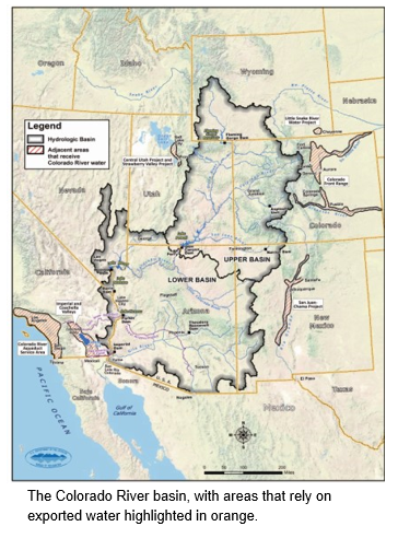
To avoid having California’s rapid growth gobble up available Colorado River supplies, in 1922 the seven states in the Colorado River basin[1] entered into an interstate compact. The Colorado River Compact (codified in article 61 of title 37, C.R.S.) allocated 7.5 million acre-feet[2] (Maf) of water per year to the upper basin states (including Colorado) and 8.5 Maf to the lower basin states, for a total 16 Maf.[3] Later, the upper basin states entered into the Upper Colorado River Compact (codified in article 62 of title 37, C.R.S.), pursuant to which 51.75% of the upper basin’s supplies were allocated to Colorado.
Naturally, the states presumed that the river’s supplies were adequate, even plentiful, to meet these allocations. Indeed, from 1905 to 1921 the flow at the boundary between the upper and lower basins was about 18 Maf. Unfortunately, the 1922 compact was negotiated during a time of relatively high flows: rather than more than 16 Maf of flow per year, actual supplies under current conditions may be as low as 14.8 Maf. Moreover, climate change is likely to reduce this supply even more:
Colorado River flows decline by about 4 percent per degree Fahrenheit increase . . . . Thus, warming could reduce water flow in the Colorado [River] by 20 percent or more below the 20th-century average by midcentury, and by as much as 40 percent by the end of the century.[4]
Despite this somewhat grim outlook, the upper basin’s ability to comply with its delivery obligation to the lower basin is enhanced by two facts:
- The 1922 compact states the delivery obligation as 75 Maf over 10 years rather than 7.5 Maf each year; and
- Numerous reservoirs with significant storage capacities are located in the upper basin. These reservoirs, including Lake Powell[5] and several reservoirs referred to as the Aspinall Unit, store excess supplies in wet years and release them in dry years to comply with the delivery obligation.
Staving off a shortage declaration through demand management. The federal Bureau of Reclamation operates the Aspinall Unit as well as Lake Powell and Lake Mead, which is the lower basin’s primary reservoir. Pursuant to an agreement[6] between the seven compacting states, the bureau operates the Aspinall Unit and Lakes Powell and Mead to maintain the water level in Lake Mead above 1,075 feet in elevation. If the water drops to that level, the bureau makes a “shortage declaration” that triggers mandatory restrictions on water diversions and usage in the lower basin. A shortage declaration may also be the first step toward a determination that the upper basin has failed to comply with its delivery obligation, which would result in the curtailment of upper basin diversions that postdate the 1922 compact.
In order to reduce the risk of a shortage declaration occurring, the upper and lower basins have both recently adopted updated drought contingency plans.[7] Congress has approved the plans.[8]
In particular, the upper basin’s drought contingency plan involves three elements:
- Augmentation, consisting of weather modification efforts to increase precipitation and the removal of phreatophytes (plants that have deep root systems that draw water from near the water table and often consume an unusually large amount of water);
- Operating the Aspinall Unit to benefit storage in Lake Powell; and
- Demand management.
Demand management in this context means, roughly, a temporary, voluntary, and compensated reduction in consumptive water use by specific water rights owners. In Colorado, demand management could involve a front range metropolitan water provider (whose water rights postdate the 1922 decree and thus whose diversions would be curtailed if the upper basin failed to meet its delivery obligation) paying a senior agricultural user on the western slope to temporarily not divert water from the Colorado River or its tributaries. The metropolitan water provider would then be able to continue to export Colorado River water to its Front Range water users. As the saying goes, water flows uphill toward money.
The General Assembly recently supported the development of demand management programs by enacting SB 19-212. The bill appropriates $1.7 million from the general fund to the department of natural resources for use by the Colorado Water Conservation Board. The board will use this money for stakeholder outreach and technical analysis to develop a water resources demand management program.
The days of hoping that Colorado River supplies will somehow recover or that the lower basin will, by some miracle, substantially reduce its water consumption enough to avoid a shortage declaration are over. Colorado is preparing for a hotter, drier climate in which water demands continue to increase while supplies diminish. Water demand management is one of the primary tools (along with conservation and the development of additional storage) that will be used to adapt to this new normal.
In the article originally posted in 2019, the author posed the question “Are increases in the price of water sufficient to address this [water] deficit?” Following is an update that suggests the answer to this question is a resounding “no”, as the Colorado River water supply continues to dwindle.
 UPDATE:[9] On August 16, 2022, the Bureau of Reclamation within the federal Department of the Interior released its “Colorado River Basin August 2022 24-Month Study”, which sets the annual operations for Lake Powell and Lake Mead in 2023 in light of critically low reservoir conditions. The key findings include:
Lake Powell’s water surface elevation on January 1, 2023, is projected to be 3,522 feet, which is 178 feet below full (3,700 feet) and only 32 feet above the minimum level required in order to continue to produce power at Glen Canyon Dam (3,490 feet). The Department of the Interior will limit 2023 releases from Lake Powell in order to protect it from declining below 3,525 feet at the end of December 2023. The Department will also evaluate hydrologic conditions again in April 2023.
Lake Mead’s water surface elevation on January 1, 2023, is projected to be 1,047.61 feet, which reflects an unprecedented shortage condition that requires shortage reductions and water savings contributions from the Lower Basin States and Mexico, as follows:[10]
-
- Arizona: 592,000 acre-feet, which is approximately 21% of the state’s annual apportionment;
- Nevada: 25,000 acre-feet, which is 8% of the state’s annual apportionment; and
- Mexico: 104,000 acre-feet, which is approximately 7% of the country’s annual allotment.
There is no required water savings contribution for California in 2023 under the current operating condition.
The Department and the Bureau of Reclamation continue to share and update information concerning the increasing risks impacting Lake Powell and Lake Mead. For more information, visit https://www.doi.gov/news.
_________________________________________________________________
[1] The seven states of the Colorado River Basin are Wyoming, Colorado, Utah, New Mexico, Arizona, Nevada, and California. The upper basin consists mainly of Wyoming, Colorado, and Utah; New Mexico, Arizona, Nevada, and California are mainly in the lower basin.
[2] An acre-foot is the amount of water required to cover one acre to a depth of one foot. An acre is about the size of a football field, including both end zones.
[3] For comparison, Colorado consumes about 5.3 Maf per year, but this includes water that has been reused multiple times. See the state water plan, Figure 5-1. https://www.colorado.gov/pacific/cowaterplan/plan
[4] http://theconversation.com/climate-change-is-shrinking-the-colorado-river-76280
[5] Lake Powell is located directly above the boundary between the upper and lower basins; releases from Lake Powell are the primary method by which the upper basin complies with the 1922 compact.
[6] Colorado River Interim Guidelines for Lower Basin Shortages and Coordinated Operations for Lake Powell and Lake Mead”, 72 FR 62272 (11/2/07); https://www.govinfo.gov/content/pkg/FR-2007-11-02/pdf/E7-21417.pdf
[7] Agreement Concerning Colorado River Drought Contingency Management and Operations; https://www.usbr.gov/dcp/docs/final/Companion-Agreement-Final.pdf
[8] Colorado River Drought Contingency Plan Authorization Act; https://www.congress.gov/116/bills/hr2030/BILLS-116hr2030enr.pdf
[9] This update was prepared by the LegiSource board, not the original author.
[10] These reductions and contributions are required pursuant to the 2019 Drought Contingency Plans and Minute 323 to the 1944 U.S. Mexico Water Treaty.