On August 2, 1876, Jack McCall entered the No. 10 Saloon in the town of Deadwood in what is now South Dakota, walked up behind “Wild Bill” Hickok, shouted a curse and “Take that!”, and shot Wild Bill in the back of the head. Wild Bill was holding two black eights and two black aces. Ever since, this hand has been called the “dead man’s hand.”
Jack tried to flee but never made it out of Deadwood. The town itself was illegal because the Lakota Sioux tribe owned the land, but then Lieutenant Colonel George Custer had led an expedition that discovered gold, so the town popped up anyway. The federal government tried to buy back the gold fields, but the Lakota were not in a selling mood. Being an illegal town, there was no real law and there were no real courts. The townsfolk put together a makeshift court and tried Jack.
Jack’s defense was that Wild Bill had killed his brother and therefore deserved death. He actually used the “he needed killing” defense. The defense succeeded; Jack was set free.
In 1872, Sitting Bull and his warriors were locked in a stalemate with Custer’s 7th Cavalry. Sitting Bull was trying to forge the entire Lakota Sioux tribe into a single fighting force. He needed to show that he was the man to lead the entire tribe. The stalemate did not bode well for his leadership and people grumbled, so Sitting Bull gathered up his pipe and tobacco and walked down to the front lines, within range of the enemy’s guns. He sat down with bullets striking all around him. He then lit the pipe and smoked it, seeming to be indifferent to the danger. After taking a few puffs, he called his men to join him. Four warriors braved it but wanted to return after taking a few puffs. Sitting Bull slowly smoked the rest of the pipe, cleaned it out, and casually walked back to his warriors. His legend was made, and, by 1876, he led the entire tribe.
The 1870s West favored the bold risk-taker.
But boldness has its cost. In June of 1876, Custer had looked over a settlement on the Little Bighorn River. Custer could not see the entire settlement, but it was bigger than any he could have expected. The Lakota Sioux, Cheyenne, and Arapaho tribes had come together to discuss war. Custer could see that he was outnumbered, but he probably didn’t understand that it was at least three to one. His biggest concern was that the tribes would melt away and fail to give him a fight. Without a fight, he could not get the victory that would put him back in the good graces of the U.S. Army.1
Custer needn’t have worried. He faced Sitting Bull and Crazy Horse, two legendary warriors who wanted to fight—especially since Crazy Horse had recently defeated the U.S. Army in the Battle of the Rosebud. A few hours later, Crazy Horse and his warriors had killed Custer and half his men and defeated the 7th Cavalry.
Two months later, Jack McCall bragged about killing Wild Bill, who was a U.S. marshal, in front of another U.S. marshal. This marshal arrested Jack. At the new trial, he was sentenced to hang. Next morning, a U.S. marshal carried out the sentence.
This may seem like ancient history that is foreign to our modern Colorado. But in 1876, the modern world was beginning to take shape. On March 10, Alexander Graham Bell made the first successful telephone call, saying the words, “Mr. Watson, come here, I want to see you.” On February 2, The National League of Professional Baseball Clubs was formed. This league became the National League of Major League Baseball.
A game is rules. Change the rules, and you change the game. Without the rules you have no game. And without rules, you have no order.
The story of 1876 is America lying by a campfire staring up into the stars. The campfire gives light and heat but also smokes and burns, and all the while the stars in the sky are distant, pretty, and spellbinding. You need the light and heat for a time, but the stars fill your dreams. In Deadwood, justice was makeshift, but in Colorado, laws and institutions were coming. For the first time, a telephone wire hummed and a curveball was pitched. The West was changing. The day before Wild Bill gazed at his dead man’s hand, the federal government and Colorado dealt a very different hand to Colorado’s citizens: statehood.
Custer had fallen out with the U.S. Army because he had traveled to Washington D.C. to testify to Congress about corrupt kickbacks. While in Washington, he had tarried for multiple reasons, including trying but failing to meet with President Grant to make peace. (Grant’s brother was tangentially implicated in the scandal.) But most people familiar with the situation suspected he tarried because he was having too much fun. Custer had been ordered to lead the 7th Cavalry west on April 6. Custer’s absence delayed the expedition by two months, so he had technically disobeyed an order, but also, he had angered the commander in chief. ↩︎
by Amanda Clapham, Legislative Council Staff Visitor Services Deputy Manager, Education and Curation
If you are a regular at the Capitol, you have walked by the “Women’s Gold” tapestry on the first floor innumerable times, and you’ve probably marveled at the brilliant colors of the stained-glass Heritage Windows in the Old Supreme Court, the Emily Griffith window on the second floor, north side, and the Virginia Neal Blue window in the Senate. (If you haven’t marveled, please walk over there and marvel immediately). These artifacts feel like they’ve been here forever. But they haven’t.
Colorado is nicknamed the Centennial State because we became a state on our nation’s 100-year anniversary. In 1976, the nation and Colorado went all out for the United States’ 200th anniversary and Colorado’s 100th. In addition to the many activities and celebrations statewide, the Capitol participated by adding several installations that are now so well established: the tapestry and the collection of stained glass.
The math nerds out there may have already gotten there, but 2026 is our 150th year of statehood! While celebrations are going on throughout the 50 states in honor of the country’s 250th birthday, Colorado’s celebration of its 150th anniversary makes us special. Senate Bill 22-011 created the America 250-Colorado 150 Commission to commemorate this unique anniversary, and the planning began there! Visit the commission’s website to learn more.
While there are activities across the state and country, we have several commemorations planned for the Capitol as well.
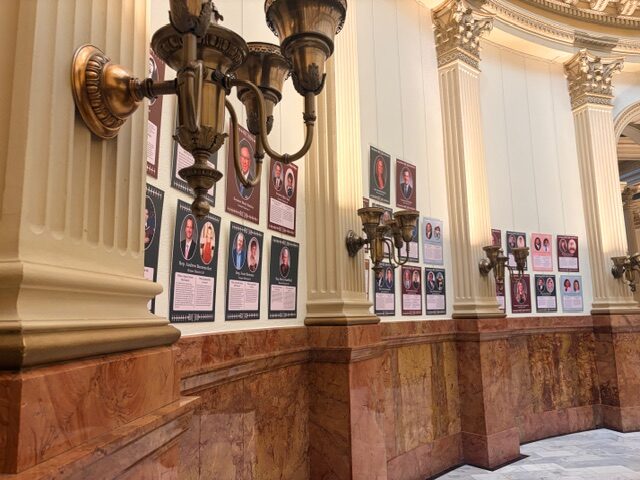
An exhibit entitled “Inspired to Serve” opened Friday February 20th; it features all 100 legislators currently serving in the Colorado General Assembly, with pictures of them now and as children. Each legislator has answered two key questions: “What inspired you to serve?” and “What is special about your district?” This exhibit will run through the end of 2026. While our building is historical, the legislature, by its nature, is always looking to the future. This exhibit is meant to inspire Colorado’s future generations to learn about civics and maybe one day run for office themselves!
You may have heard that the official sea level in the United States has changed, making our Mile High Marker incorrect! Capitol staff is working with the Colorado School of Mines to re-measure our treasured marker that resides on the West Steps. If you’re a Capitol nerd, you know that there are three Mile High Markers currently embedded on three different steps, originally measured in 1909 (15th step), and then re-measured in 1969 (18th step) and 2003 (13th step). Both sea level and the accuracy of measurement techniques have changed over time. It’s the latter that the School of Mines will explore as they measure for us, again. Engineering Professor Jeff Holley and his students will be using old surveying techniques as well as GPS to give us the real mile high measurement for 2026.
In Mr. Brown’s Attic, the space above the third floor of the Capitol, there is a scale model of the Capitol building, which is really popular, especially with kids. And what is more popular with kids of all ages than LEGO? The Denver Lego Users Group will be building a scale model of the House and the Senate for the 2026 celebrations. Both fun and colorful, these models will draw the attention of visitors of all ages and act as a gateway to civic education.
In addition to these exciting projects, the Capitol will be working with History Colorado as well as other cultural, educational, and civic organizations throughout the state, to create one of our biggest and best Colorado Day celebrations EVER! Join us on August 1, 2026, for bands, food, history, entertainment, and some special surprises! Events will take place in Civic and Lincoln Memorial parks, on Broadway, from History Colorado to Colfax, and inside and on the West Steps of the Capitol Building.
This commemoration isn’t just about Colorado’s past 150 years, but also who and what we are as a state right now. It is our chance to tell the future what is important to us (and also to have some fun!).
In February 1861, with Abraham Lincoln about to take office and the Civil War just weeks from breaking out, President James Buchanan signed legislation establishing the Colorado Territory. Immediately, the territory’s first governor, William Gilpin, began thinking about where the capital of the new territory would be. Towns up and down the Front Range vied for the honor, and in the territory’s first years, the center of government moved from Colorado City to Golden and finally, in 1867, found its home in Denver. Now it was time for political leaders to think about a site for a statehouse.
Money was tight, so when contractor and builder Henry Cordes Brown offered government officials a 10-acre swath of land south of town as a gift, they jumped at the opportunity. Years of fundraising followed. In the centennial year of our nation’s founding, Colorado became a state, and soon after, the General Assembly set aside money for a capitol building. Finally, in 1885, a plan and an architect, Elijah Myers, were chosen.
At a time when Colorado’s population stood at 200,000, Myers had an interesting idea: Every agency of state government, including boards, commissions, and all the public servants who worked for those agencies, would be housed within the walls of his simple but grand building. The structure would be so large that it would serve the new state as the sole state government building for generations to come.
When the State Capitol was finally completed 15 years later, Myers’s grand vision was realized: The legislature’s beautiful bicameral chambers shared a floor with the Colorado Supreme Court. The governor’s office sat across from the offices of the state treasurer, attorney general, and five other executive branch officers. And, perhaps most interesting, on the main floor Myers set aside space to showcase the most powerful influences in nineteenth-century Colorado: Mining, agriculture, and land management.
Walking into the statehouse in its early years was like visiting a museum featuring all that Colorado had to offer. In the west wing, collections from the State Historical and Natural History Society were on display, including pottery, tools, and baskets from Mesa Verde; stuffed birds, bison, bears, and bighorn sheep from Colorado’s mountains and plains; and Civil War-era cannons, firearms, and banners used in the Battle of Glorieta Pass. Down the hall, glittering minerals and polished stone filled cabinets in the Bureau of Mines quarters. In yet another room, the State Horticultural Society displayed the trees, flowers, fruits, and vegetables grown in Colorado. There were even quarters where Union Civil War veterans could gather (until they were evicted in 1897 for too much card playing and carousing).
The treasures found on the Capitol’s main floor, along with the brass chandeliers, marble floors, rose onyx walls, and soaring rotunda above, attracted tourists in droves. But the dome itself was the most important element, marrying the functions of government with the natural beauty that encircled the building. An observation deck offered sightseers, as Myers had hoped, “an unequaled view of the surrounding country.” The architect knew the panorama of the Rocky Mountains from Pikes Peak to Longs Peak was the building’s greatest feature.
As the nineteenth century came to a close and the twentieth century dawned, a variety of embellishments were added. A sweeping staircase rose through the center of the rotunda, replacing cast-iron staircases in the north and south atriums. The copper-plated dome, which quickly oxidized, was covered with gold leaf in a glittering nod to the Pikes Peak gold rush. Brightly colored stained-glass portraits of Colorado pioneers were installed in the rotunda.
Some of these changes were in tune with Myers’s original vision. Others were not. But the building’s greatest promise, that it would hold every office and function of Colorado government for generations, quickly shattered. By 1907, so many new agencies and commissions had been created that the statehouse had reached its limit. Fewer than 10 years after the Capitol’s grand opening, its managers were looking for a place to expand.
Today, though shiny minerals and taxidermied mammals no longer fill the first floor of the statehouse, the grandeur and beauty of the Gilded Age still make the Colorado Capitol an attraction to tourists from throughout the state, the country, and the world.
To learn more about the planning, construction, and evolution of the Colorado statehouse, see Derek R. Everett’s book, “The Colorado State Capitol: History, Politics, Preservation,” University Press of Colorado, October 1, 2018, on which this article is based.
On June 25, 2020, protesters pulled down the statue of the civil war soldier that stood atop the pedestal monument near the west steps of the Colorado capitol. Since that day, legislators and members of the American Indian community have discussed a replacement monument. But, to this day, the space where the civil war soldier statue once stood remains empty.
The original plan to replace the civil war soldier with a statue of an American Indian woman mourning the events of the Sand Creek massacre was approved by the Capitol Building Advisory Committee in November 2020. The Committee based its decision on a seven-inch prototype of a statue by the artist Harvey Pratt.
In March 2022, however, more than a year after the Capitol Building Advisory Committee sent its recommendation to Capital Development Committee, Mr. Pratt withdrew his statue from consideration. Representatives of the Northern Cheyenne and Northern Arapahoe tribes asked Mr. Pratt to make modifications to his design, and the artist declined their request. This development sent the proponents of the new monument back to the drawing board.
On May 17, 2024, the Capitol Building Advisory Committee met again and heard testimony from the tribes’ representatives regarding the status of the memorial. During the meeting, the representatives announced that they had agreed upon a new design. A team of four individuals, including a representative from each of the two tribes, a Denver sculptor, and a project architect from the University of Denver collaborated to develop a new concept and enlist a new sculptor to execute it.
The supporters of the new design described the proposed new sculpture as a bronze structure in the likeness of a tepee, with visible poles, to be placed on the ground rather than upon a pedestal. The new monument would be placed on a circular pad on the site of the former monument.
The proponents estimated the cost of the new monument at somewhere between $200,000 and $300,000. They expressed their hope that the One Earth Foundation would pay the bulk of this amount, but they also indicated their hope that the Capital Development Committee and the legislature will chip in some portion of the costs to pay for site preparation.
On November 15, 2024, the proponents appeared again before the Capitol Building Advisory Committee to share a miniature prototype of the new monument. Sculptor Gerald Shippen presented a slide show that displayed the prototype from various angles and perspectives. The planned monument will depict three Native American figures standing before a tepee without any walls — only poles. The figures will be larger than life — about seven feet tall — and the poles of the skeletal tepee will be approximately 23 feet high.
The prototype of the monument depicts an American flag hanging from the highest tepee pole, but according to Mr. Shippen, the plan is to incorporate this design element only on special occasions. For example, when the tribes hold the annual Sand Creek Massacre Spiritual Healing Run, the tribal runners will approach the west steps of the capitol and lay a ceremonial lodge pole on the tepee. The lodge pole will display a United States flag and a white flag of peace, which were the flags that Chief Black Kettle of the Southern Cheyenne had displayed on his tent on the day of the Massacre.
The Committee voted unanimously to approve the design and recommend it to the Capitol Development Committee.
Colorado City as the capital of Colorado, or Golden? Residents may be surprised to learn that Denver has not always been the capital city of Colorado. In fact, these three cities have each been chosen as the capital throughout Colorado’s state and territorial history—all within the course of seven years.
In 1861, the first Territorial Legislative Assembly (Assembly) of the newly established Colorado Territory was tasked with determining the location of the Colorado territorial capital. Before 1861, Colorado was included in the Kansas Territory, with the territorial capital located in eastern Kansas. The new territorial capital of Colorado was determined that fall during an Assembly meeting on G and Larimer Streets in Denver. The Assembly chose Colorado City, which is today part of Colorado Springs after its voluntary annexation in 1917.
Colorado City was a small settlement, briefly known as El Dorado, created in 1859. It was the first lasting town within the Pikes Peak area. Colorado City was more centrally located than Denver in the Colorado Territory and, at the time, was the main line to Ute Pass, making it an easy supply stop for miners and settlers coming from the central Plains, such as Kansas or Missouri. Alternatively, northern settlers coming from Wyoming and Nebraska traveled through Denver and those coming from the southern states mostly came up through Pueblo. Many investors were interested in the location of Colorado City, which also may have influenced the decision to put the territorial capital there.
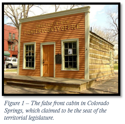
The second meeting of the Assembly in Colorado City, in July 1862, would be the first and last legislative session with the town as the capital. The lack of accommodations and facilities made the town a challenging, uncomfortable place for legislators to convene.[1] With no Capitol building or accommodations to create a home base, legislators would ride on horseback to the area and sleep on the ground when they reached Colorado City before meetings with other members of the Assembly. There wasn’t “even paper or pen” for notetaking.[2]
Today, there is a false front log cabin in Colorado Springs that supposedly represents the building where the Assembly convened, but according to historical sources, this site was only a place where legislators informally conversed. Their true meeting locations were the Francisco House for the Senate and Lucy Maggard’s boarding house for the House of Representatives. The working environment, which was sparse and ill-equipped, sparked frustration, and only four days after meeting, the members chose to reconvene in Denver instead.
The Assembly quickly decided that the next capital should be Golden. Founded in 1859, the City of Golden was the official capital of the Colorado Territory between 1862 and 1867. However, the Assembly met in both Golden and Denver, then known as Denver City, during this time. Denver City, founded in 1858 (named after the Kansas Territorial Governor James Denver), was a more bustling town than Colorado City, while Golden was a manufacturing hub with nearby access to booming mining towns and camps. Golden’s thriving miner-friendly location made it a more comfortable town to convene in than Colorado City had been.
William Loveland, an influential legislator and local businessman in Golden, offered his store up to the Assembly as a place to meet. He encouraged members “to come to the store to accept new suits of clothes, the ones they were wearing being in bad shape from so much traveling.”[3] The Assembly met in the Loveland Building many times during Golden’s time as capital. However, working without a permanent Capitol building meant that whenever the members wanted to convene, archives and furniture were carted across the Front Range and foothills by wagon to the meeting location. Many in the public and press saw this as a shabby affair, beneath the dignity of an official legislature, and ultimately the Assembly only met in Golden five times, often adjourning to Denver.
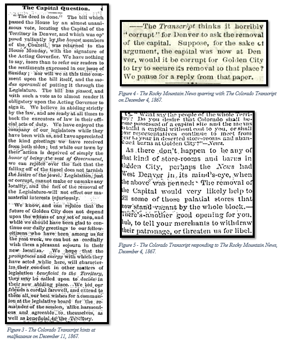
For a week in December 1867, while meeting in Golden, the Assembly sparred over where the capital should be, debating between Denver and Golden. The mountain faction, representing miners and anti-Denver sentiment, steadfastly defended Golden as the proper seat of government. In the end, the Denver faction won by a single vote, and the mountain faction suspected bribery, potentially over the railroad interests at stake. Opposition to the capital move to Denver sparked a spirited article war in local newspapers, The Colorado Transcript (Golden) and The Rocky Mountain News (Denver), with The Colorado Transcript hinting that votes for Denver were based on corruption.
On December 9, 1867, the Assembly officially passed the act making Denver the capital city of the Colorado Territory, with the condition that Denver donate the land where the Capitol building would be built. Three territorial commissioners were appointed to select a site for the Capitol within 60 days of their appointment. The land needed to contain at least ten acres and be given to the Colorado Territory at no cost. Land fitting this description was donated in 1868 by carpenter and ambitious businessman, Henry Cordes Brown, who had originally bought the land for $12.50. However, by 1875, the Capitol had not yet been built and members were still meeting in “rented rooms and warehouses.” When Colorado became a state in 1876, there was no guarantee Denver would remain the capital, and tensions were mounting across the state. It made little sense to build an expensive Capitol building in downtown Denver if the state capital would be located somewhere else. The lack of construction on the land in Capitol Hill made Brown increasingly unsettled, and in 1879 he filed a deed of revocation to reclaim the land. Brown’s legal battle lasted seven years, making its way to the United States Supreme Court in both 1882 and 1886. The Supreme Court ruled for Colorado, and Brown’s bitterness toward the situation led him to later boycott attending the dedication of the building on July 4, 1890.
It was not until 1881 that Denver, no longer Denver City, was made the official state capital by a statewide referendum. Cities like Colorado Springs, Pueblo, and Canon City were considered, but after over 45,000 votes were counted, Denver received an easy majority of the vote. Construction on the current Capitol building began in 1886, and the Colorado state legislature did not meet in the Capitol until 1895.
So it is that Denver is the last of the territorial capitals in Colorado and the only state capital we have known. Denver grew into a major city, and the Colorado State Capitol has become a symbol of permanency and elegance for Colorado’s legislators and civilians alike.
[1] If the legislators had met in August 1862 instead of July, there would have been adequate lodging for the legislators, according to the Old Colorado Historical Society.
Abbott, Carl, Stephen J. Leonard, and Thomas J. Noel. Colorado: A History of the Centennial State, Fifth Edition. University Press of Colorado, 2013. http://www.jstor.org/stable/j.ctt4cgqpb
“FROM THE CAPITAL: The Fight on the Capital Question—A Long Debate—A Great Speech by Mr. Belden, of Gilpin County.” The Rocky Mountain News (Daily). December 6, 1867.
Colorado’s laws concerning gambling, or gaming, were, until recently, unique among the states. However, the tight and unusual restrictions that were associated with Colorado’s embrace of “limited gaming” in 1990 have now disappeared. Legally, our state now looks more like other states that have embraced for-profit gambling over the last 30 years. What happened? Well, here is a quick summary of the evolution of gaming law in Colorado!
The Wild West: Gambling is a popular pastime in late-nineteenth-century Colorado. In frontier towns and mining communities, the absence of law enforcement allows gambling to flourish in saloons and brothels. In Denver, during Colorado’s silver boom, the legendary con man Jefferson Randolph “Soapy” Smith II operates gaming halls and rigged games that target successful silver miners and their newfound wealth.
The silver boom eventually dies out and the miners move on, but migrant workers and families continue arriving to populate the new state of Colorado. As conservative values begin to prevail and local, state, and federal law enforcement agencies are established in the West, gambling is forced out of public spaces.
1948: Colorado voters approve a legislatively referred measure called the Colorado Gambling on Horse and Animal Races Amendment. The new law allows betting on horse races and greyhound races and creates the Colorado Racing Commission. In 1949, live horse racing and greyhound racing begin in Colorado.
1958: Through another ballot measure, Colorado voters amend the state constitution to allow charitable gaming, including bingo and raffles, beginning in 1959.
1982: The Colorado General Assembly creates the Colorado Lottery and the Lottery Division of the Colorado Department of Revenue. In 1983, the Colorado Lottery begins selling tickets.
1990: Voters overwhelmingly (57.3% to 42.7%) pass Amendment 4, a citizen-initiated measure called the Legalization of Limited Gambling Initiative that legalizes “limited gaming” only in the mountain towns of Black Hawk, Central City, and Cripple Creek. In 1991, the initiative becomes law and casinos begin operations. Individual bets can be no more than $5, casinos’ hours of operation are limited to 8 a.m. to 2 a.m., and roulette and craps are not allowed.
2000: Colorado voters enact Referendum E, a legislatively referred measure that allows the state lottery to begin offering tickets to multistate jackpot drawings such as Powerball and Mega Millions.
2008: Through yet another citizens’ initiative (Amendment 50), Colorado voters amend the state constitution to increase the maximum individual bet amount from $5 to $100, allow casinos to operate 24/7, and allow casinos to offer roulette and craps games.
2014: The Colorado General Assembly enacts House Bill 14-1146, which prohibits greyhound racing in Colorado.
2019: Voters narrowly (51.4% to 48.6%) approve Proposition DD, which legalizes sports betting in Colorado. In May 2020, in the midst of the COVID-19 pandemic and associated lockdowns, sports betting – including online sports betting – launches in Colorado. The operations of new sports books in Black Hawk, Central City, and Cripple Creek casinos are initially limited by the situation. But TV and radio advertisements for online sports betting websites suddenly become ubiquitous in Colorado media.
2020: Colorado voters overwhelmingly (60.5% to 39.5%) embrace Amendment 77, which essentially removes any limits on the size of bets and the types of games allowed in Colorado casinos.
2023: The Colorado General Assembly enacts House Bill 23-1041, which prohibits wagering on greyhound races that are conducted on out-of-state tracks and simulcast in Colorado.
In Part 1 of this series, we explored how the US created its states, prioritizing geometric simplicity over geographical variance. Colorado stands uniquely symmetrical and rectangular among other states, and Part 2 of this series will examine how Colorado’s shape and dimensions were placed – and why its borders have been so controversial.
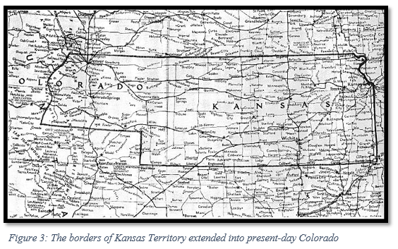
Throughout its history, Colorado has been under the control of France, Spain, Mexico, the Republic of Texas, and the US. The Rocky Mountains formed a natural barrier between the American-owned Louisiana Purchase lands and the area belonging to Spanish Mexico. What would become the western and southern parts of Colorado were acquired by the US government through the Treaty of Guadalupe Hidalgo. Before the Anglo population grew in Colorado, the land was occupied by several indigenous tribes, including the Ute, Jicarilla Apache, Arapaho, Anasazi, Navajo, Comanche, Cheyenne, Kiowa, Pueblo, and Shoshone. Many of these tribes were forced to consolidate or give up their land when white settlers moved into the region. When Kansas Territory was created in 1854, most of central Colorado and the eastern plains were absorbed into Kansas; the parts of Colorado that lay west of the Rocky Mountains had become part of Utah Territory in 1850.
Following the Pike’s Peak gold rush of 1858-1860, the Front Range and foothills of the Rocky Mountains became more heavily populated, with most of the growth attributed to young and single male miners. The population would diminish over the following years as the spoils of the gold rush faded and the lawlessness of the region made the area unsettling for young families.
With Kansas Territory’s capital being in eastern Kansas, inhabitants of present-day Colorado began to wish for a closer form of government, as well as more locally-enforced law enforcement of the region. In November 1858, Denver residents elected a delegate to the US Congress to officially request that Congress create a new territory.
Colorado’s request was particularly troublesome, as the territorial population was strongly Republican, and Southern Democrats were concerned they would not find support in the area. In the heat of deadlock over the slavery debate, Congress would refuse to act on this request until 1861.
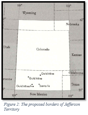
In 1859, Colorado residents decided to take matters into their own hands and, without congressional approval, formed Jefferson Territory, named after the president who had overseen the Louisiana Purchase. For a year and a half, the territory illegitimately elected officials, created territorial boundaries, and established a legislature that adopted legislation related to personal and civil rights. The enlarged borders of Jefferson Territory would have made Colorado about 70% larger than it is today and would have included areas within Wyoming, Nebraska, Utah, and Kansas. This additional land would have contained much of the gold and silver of the region for mining and would also have brought the territory agricultural land, diversifying the economy of the territory from relying entirely on mineral resources. Geographically centering the Rocky Mountains within Jefferson Territory, rather than placing the mountains at the borders, would also “prevent disputes over profitable mining claims.”[1]
Creating a provisional territory was not unusual. Other parts of the country had instituted provisional governments until Congress officially recognized territorial governments: Deseret became Utah and the State of Franklin became Tennessee. Jefferson Territory adopted a similar extralegal approach until Congress had established an official territory.
A census found that Colorado was occupied by only 34,277 residents in 1860, making it too small to be a state but large enough for another structure of government. And most Colorado voters refused to vote for statehood when they had the opportunity in 1864, due to the higher taxation associated with new statehood. As a territory, the federal government footed the bills; however, this made the extralegal entity of Jefferson Territory unable to collect taxes from residents.
Jefferson Territory ceased to exist when Congress and President Buchanan created the Colorado Territory on February 28, 1861. Members of Congress opposed naming states and territories after individuals, so the name Jefferson was dropped. Although some legislators favored naming the new territory “Idaho,” the delegate from Colorado successfully convinced legislators that “Colorado” would be a more fitting name, as the Colorado River started within the territory. Jefferson County is the sole remaining county from Jefferson Territory.
In the 1860s, there were several attempts by residents to make Colorado a state, but with Civil War and Reconstruction era policies dividing up the political scene in Washington, Colorado was not admitted as a state until 1876.[2]
The Borders of Colorado
The eastern border of Colorado was determined by Kansas’ western border when Kansas achieved statehood in 1861, only a month before Colorado Territory was created. A contentious statehood debate raged over the possibility of a “Big Kansas,” which would have included large swaths of Nebraska and possibly areas of Colorado that had already been part of Kansas Territory. Some Kansans raised concerns over how the population of the mining areas in Colorado would upset the balance of power in Kansas. During the 1859 Wyandotte constitutional convention in Kansas, some local delegates claimed that eastern and western Kansas Territory varied too widely in culture and politics or that the Kansas government was too far away from the mining areas of Colorado to provide much responsiveness; linking these areas permanently in statehood would raise the potential for conflict. Others were concerned with the cost of having such a large state, with Republican delegate and future Kansas congressman M.F. Conway stating, “Had we retained the Pike’s Peak region, the mere mileage of the members of the Legislature and officers going to and returning from the State capital would more than exceed the cost of the whole State government.” Political divisions were clear on the matter, as “many Democrats opposed the exclusion of the western territory, while many Republicans approved of the rejection.”[3]
The arguments for keeping part of present-day Colorado with Kansas were resource-driven. Some wanted the wealth of the mining industry in the Rockies to flow to Kansas, and others believed that the railroad builders would look favorably upon investing in Kansas with its connections to Colorado mineral resources. A few members of the convention argued that cutting off the Rockies and their mining settlements would bring the population of Kansas down to a point where statehood would be off the table, as territories needed to cross a certain population threshold to become a state.
In 1859, the Wyandotte constitutional convention agreed with the “Little Kansas” proponents, which gave the state of Kansas its current size. Creating a homogenous Kansas and allowing the miners to create a government for their region was well-received in both Colorado and Kansas.
When Colorado residents, including many miners, drew the boundaries for the extralegal Jefferson Territory, the same line was drawn with Kansas, exemplifying inhabitants’ agreement with Kansas’ proposed boundary line. Kansas became a state in 1861, solidifying the boundaries voted on in the Wyandotte constitution.
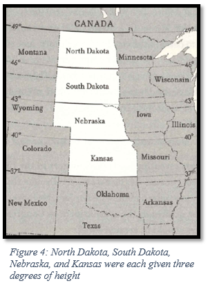
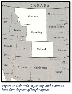
Congress drew Colorado’s western borders according to the equitable principles outlined in Part 1, and with the western landscape largely open, Congress had a chance to make border divisions as equal as possible. The prairie states of North Dakota, South Dakota, Nebraska, and Kansas all have three latitudinal degrees of height. Colorado, Wyoming, and Montana have four latitudinal degrees of height – the extra degree, given out of fairness, allows for the less arable agricultural land these states share. Colorado, Wyoming, the Dakotas, Oregon, and Washington also have nearly seven longitudinal degrees of width per state. This was intentionally done to promote border equality in the western states. Therefore, the western border Colorado shares with Utah was drawn to give the state seven longitudinal degrees of width from the border with Kansas.
The northern border of Colorado was initially proposed to be drawn at the 42nd parallel, aligning with a 1790 agreement called the Nootka Convention, which was signed between England and Spain as a way of dividing their interests in western North America. This line currently provides borders for Oregon, California, Idaho, Nevada, and Utah.
However, Congress wanted to ensure that four longitudinal degrees of height in Colorado were observed, so the northern border was lowered by a degree, as the southern border with New Mexico Territory had already been loosely planned in 1850. This allowed Wyoming and Montana to have four longitudinal degrees of height when they became states years later.
The northern border of Colorado was initially proposed to be drawn at the 42nd parallel, aligning with a 1790 agreement called the Nootka Convention, which was signed between England and Spain as a way of dividing their interests in western North America. This line currently provides borders for Oregon, California, Idaho, Nevada, and Utah. However, Congress wanted to ensure that four longitudinal degrees of height in Colorado were observed, so the northern border was lowered by a degree, as the southern border with New Mexico Territory had already been loosely planned in 1850. This allowed Wyoming and Montana to have four longitudinal degrees of height when they became states years later.
Colorado’s southern border with New Mexico was largely determined by the territorial acts of Utah and New Mexico in 1850 and has been rooted in controversy and violence. Colorado residents initially lobbied for Jefferson Territory to include northern New Mexico. There were several gold mines in the north central part of New Mexico Territory, and Coloradans wanted access to as much gold as possible to sustain its thriving mining industry. This expansion also unconstitutionally included a corner of Texas. When Congress set the southern border at the 37th parallel, it did so with the same logic that determined Colorado’s northern border – a desire to create a column of states with the same height and width. Simplicity of shape and size were prioritized over geography, and the border setting truncated the Hispano population in the San Luis Valley of New Mexico Territory. This set off animosity at the local level and in Congress.
In May of 1862, the House of Representatives debated dividing New Mexico in order to create Arizona Territory, and New Mexico’s delegates voiced anger over Colorado’s border with New Mexico Territory. John S. Watts, the delegate from New Mexico, recalled how residents of the San Luis Valley were betrayed when Colorado Territory was made “merely for the purpose of beautifying the lines of the new Territory of Colorado.” The following year, New Mexico’s legislature expressed resentment at the loss of territory and memorialized Congress about the boundary with Colorado, which had been left unsurveyed. New Mexico claimed that Colorado had taken advantage of the unsurveyed land and had started exercising their authority much further south than they were entitled to.
In 1865, New Mexico delegate Francisco Perea spoke before the House Committee on the Territories in favor of bringing the San Luis Valley settlements back into New Mexico Territory. He derided the “evenness and symmetry” of Colorado’s southern boundary, stating that the focus on a straight border cut off a fertile part of New Mexico and betrayed the long-standing interests of people who had always belonged to the rest of the New Mexico Hispano culture. His sentiments were echoed by the Santa Fe Weekly Gazette, which wrote that although clean-cut borders were pleasing to the eye, the border setting between New Mexico and Colorado did a disservice to the local population of Hispanos. In the end, Congress refused to change Colorado’s southern border, beyond addressing small surveying inaccuracies.
Surveying ambiguities over the exact location of the border were left unresolved by Congress over the years, despite mounting frustration from New Mexico. In 1925, the US Supreme Court deemed that although a more accurate survey of the border existed, the boundary in force took precedence over a later survey. This confirmed that New Mexico would officially lose thousands of acres to Colorado.
So it is that Colorado stretches from 37 degrees to 41 degrees latitude and 25 degrees to 32 degrees longitude. And you might be surprised to learn that it does not have four sides, but 697 – due to a large amount of small surveying errors. There have been attempts to change Colorado’s borders; as recently as 2013, northeastern Colorado county commissioners encouraged a small movement for the area to become its own state, which would be known as North Colorado or New Colorado. This was mostly a symbolic discussion, as some Colorado counties wanted to make a statement against policies being made at the state level. The boundaries determined by the state constitution in 1876, however, have not changed since Colorado became a state.
Colorado’s borders were influenced by a desire by the US government to create states of equitable size, placing a priority on geometric design instead of working around or with geographic barriers. Colorado’s four borders are consistent with this policy and have given us a uniquely symmetrical shape and size on the nation’s map.
[3] Gower, “Kansas Territory and Its Boundary Question.”
References
Abbott, Carl, Stephen J Leonard, and Thomas J Noel. Colorado: A History of the Centennial State. Fifth. Boulder, Colorado: University Press of Colorado, 2013.
History, Art & Archives: United States House of Representatives. “Draft Bill for Colorado Territory | US House of Representatives: History, Art & Archives.” history.house.gov. Accessed June 6, 2023. https://history.house.gov/HouseRecord/Detail/15032436207.
History Colorado. “Carving up a Continent: State Boundaries in the American West, Feat. Dr. Derek Everett.” www.youtube.com, October 5, 2021. https://www.youtube.com/watch?v=EUit0Mj5QH8.
Library Of Congress, and Sponsoring Body Library Of Congress. Center For The Book. How the States Got Their Shapes. Washington, D.C.: Library of Congress, -07-15, 2008. Video. https://www.loc.gov/item/2021687996/.
Looking at a map of the United States, one spots a difference between the symmetrical states in the West and the more irregular borders of the East. At first glance, Colorado seems to have been easily drawn with its four clean borders. But why don’t we have the winding borders the eastern states have? Why are our mountains in the middle of the state, rather than drawn as a border? Is there a reason for the way our state cuts into part of Nebraska? This two-part series will address these questions and more, showing how the placement of Colorado’s state and territorial lines was part of a grander vision for political and cartographical harmony across the United States.
Throughout its history, the US has drawn its state and territorial borders according to geometry, with a focus on equity between the states and their resources. The Confederation government (1781-1789) solidified the Enlightenment-era precedent of drawing boundaries in straight lines through several ordinances in the 1780s, creating a distinct preference for geometry over geography. Most scholars of boundary-making have expressed disapproval of this approach, with historian James Bryce writing in the 1880s that state lines “are for the most part not natural boundaries fixed by mountain ranges, nor even historical boundaries due to a series of events, but purely artificial boundaries determined by an authority which carved the national territory into strips of convenient size.”
In the US, only part of a single state line follows a chain of mountains; this line lies along the Continental Divide dividing Idaho and Montana. Only one-third of states incorporate rivers into their boundaries, and outside of relatively small surveying errors, American states are generally neat and well-defined. It was always the intention of the US government to create cleaner boundaries based on straight lines, rather than borders based on unpredictable natural barriers. This explains the confusion over the state boundaries here in Colorado, as according to historian Derek Everett “geographically, there is no sensible reason for the state of Colorado to exist….[T]he simple rectangle that demarcates Colorado’s boundaries affords practically nothing…capable of bringing this disparate region into a single political entity.”[1]
However, in spite of the criticism aimed at geometric boundary-making, drawing lines based on geography has its drawbacks. Rivers are unreliable boundaries because they change dramatically over time; there have been several issues with the Missouri River as a boundary-maker over the years, as parts of Nebraska were found on the Missouri side of the river in the 1870s. Only the most entrenched and immovable rivers can realistically be used as boundaries, but these make up a very small portion of rivers. When the western states were being divided, there was a bit of public support for placing major rivers in the center of states instead to encourage riverine city and commercial development, but these petitions ultimately failed to convince Congress.
Mountain ranges as natural barriers are also difficult to use as state lines. It would be enormously difficult to survey a mountain range from peak to peak and cleft to cleft in all kinds of weather, even with modern technology. In the 1890s, scientist and explorer John Wesley Powell recommended state and county lines be drawn according to river basins, which are far less changeable over time than rivers, and also prioritize natural boundaries over geometric lines. There were many limitations with his plan for law enforcement and land ownership, and his suggestions came after the continental US had been divided up; therefore, it was too late to practically consider implementing Powell’s proposal.
Congress attempted to create equality between states, drawing lines in order for states to share access to water, agriculture, and maintain relative equality of size. States that are far larger than others, such as California, Texas, and Alaska, are states that created themselves. When Congress asked California and Texas to readjust their borders after admittance to the Union, few borders were actually altered, and the economic benefit of these states being part of the US outweighed the high risk of alienating them to preserve boundary equality.
Slavery was another integral piece of boundary making. To maintain an uneasy peace in the years leading up to the Civil War, the North and South would admit a slave-owning state when they would add a free state. This tit-for-tat division influenced the border placement of many states near the 36th and 37th parallels.
Even as new territories and states were in the offing, the US Congress had an eye on the future. Congress placed an emphasis on intentional planning, allowing for and encouraging the explosive growth in the West. The tapestry of our nation could very well have been checkered with states of different sizes, shapes, and names from what exist today, if it hadn’t been for the vision of equity and symmetry championed by our Enlightenment thinkers.
Stay tuned for Part 2 of this piece next week, which will explore the reasons behind Colorado’s borders, and how they have changed over time!
Abbott, Carl, Stephen J Leonard, and Thomas J Noel. Colorado: A History of the Centennial State. Fifth. Boulder, Colorado: University Press of Colorado, 2013.
History, Art & Archives: United States House of Representatives. “Draft Bill for Colorado Territory | US House of Representatives: History, Art & Archives.” history.house.gov. Accessed June 6, 2023. https://history.house.gov/HouseRecord/Detail/15032436207.
History Colorado. “Carving up a Continent: State Boundaries in the American West, Feat. Dr. Derek Everett.” www.youtube.com, October 5, 2021. https://www.youtube.com/watch?v=EUit0Mj5QH8.
Library Of Congress, and Sponsoring Body Library Of Congress. Center For The Book. How the States Got Their Shapes. Washington, D.C.: Library of Congress, -07-15, 2008. Video. https://www.loc.gov/item/2021687996/.
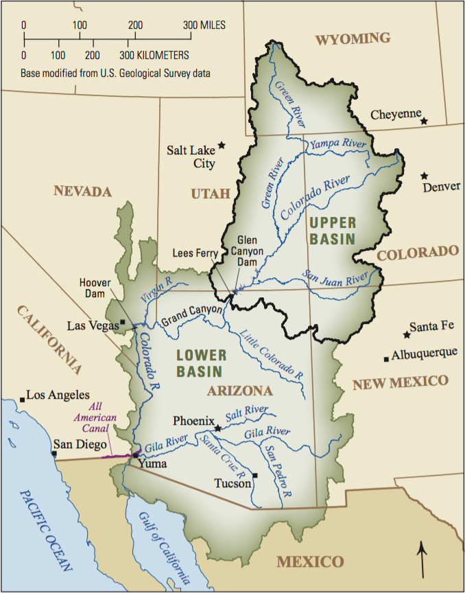
The Twenty-fourth Session of the Colorado General Assembly convened on January 3, 1923, with its members poised to pass cornerstone water and conservation legislation. This session would change how the Colorado River is allocated, address wildlife preservation, establish Armistice Day, and enhance care for children and the blind in Colorado.
The Colorado River Compact
One of the most important pieces of legislation passed in 1923 was the approval of the Colorado River Compact, which had been signed in Santa Fe, New Mexico, on November 24, 1922. Governor-appointed commissioners from Arizona, California, Colorado, Nevada, New Mexico, Utah, and Wyoming attended a conference in early November 1922 to determine how the river water should be allocated between the Colorado River Basin states. Many of the Basin states were newly concerned with securing their state’s water supply due to California’s robust population growth and a U.S. Supreme Court ruling from June 1922, which had declared the law of prior appropriation; this law expressed that, “whoever used the water first had first right of use in times of shortage … regardless of state lines.” The states had an urgent need to come to an equitable agreement to prevent California from requesting water other Basin states believed they had rights to instead.
The Colorado River Compact was the first time in American history when more than three states came together to distribute the waters of a stream or river, and it became the bedrock for the “Law of the River” — the series of laws and contracts that regulate the use of the Colorado River. The agreement effectively ended navigation and commerce on the river and prioritized the value of the water for domestic and agricultural needs.
The Compact was not binding until each of the Basin states approved it within their state legislatures and the U.S. Congress ratified it. The General Assembly in 1923 determined that the act was “necessary for the immediate preservation of public peace, health, and safety”, and the act was approved on April 2, 1923. Only six of the seven states needed to ratify the compact, and the Colorado River Compact officially took effect in 1929. Arizona would not ratify the agreement until 1944 due to the state’s concerns with the way the Compact allocated water to the Upper and Lower Basins rather than to each of the states directly.
The Compact also raised the future question of Mexican ownership over areas of the Colorado River. Water allocations to Mexico were addressed in the Mexican Water Treaty of 1944.
Colorado Game and Fish
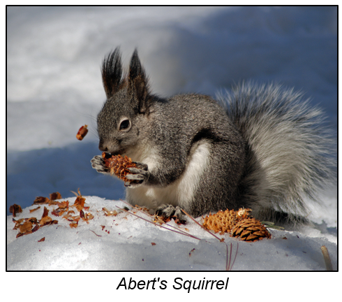
The General Assembly established several state game refuges in 1923 to regulate and prohibit the killing of certain protected game in Colorado. Violators of state game refuge laws would be guilty of a misdemeanor and punished by a fine of up to $100 and/or imprisonment for up to 60 days in the county jail. The restrictions seem to have been successful for at least one protected animal – the Abert’s Squirrel, which currently ranks as an animal of “least concern” for extinction.
The 1923 legislation outlined particular limitations on game hunting, including a declaration that there would be no open season on partridges. A maximum of eight geese could be killed or found in a person’s possession in a single day, and only one deer and one elk could be killed by an individual in the entirety of the hunting season. The laws imposed by the 1923 General Assembly were an extension of Colorado’s wildlife protection legislation, which was initially passed to preserve game and fish in Colorado Territory in 1870.
Armistice Day
In 1923, the General Assembly changed “Liberty Day”, which was established in 1919, to “Armistice Day.” Legislation established Armistice Day on November 11 each year to commemorate the success of the Allies “against Germany and the survival of liberty and democracy at home and abroad.” Congress passed a resolution in 1926 for annual observance of the holiday, but by that time 27 state legislatures had already turned the day into a legal holiday. In 1938, Armistice Day became a national holiday, and in 1954 Armistice Day became “Veterans Day”.
In 1968, a controversial new federal law changed the date of Veterans Day from the eleventh day of November to the fourth Monday in October to provide federal employees with a consistent three-day weekend. The first year of observance for the new date was 1971, but two states refused to switch the date, and veterans groups ardently opposed the change. In 1974, several newspaper editorials called for Congress to restore November 11 as the date of observance, and a few months later, 46 of the 50 states ignored the federal celebration in October, opting to switch back to the November 11 date or refusing to move the holiday altogether. In 1975, President Ford amended the Uniform Monday Holiday Act and changed Veterans Day back to November 11. Veterans Day has fallen on November 11 since 1978.
Care for Neglected Children and the Blind
Several acts were approved in 1923 to assist with the care of children, mothers, and the blind. The State Home for Dependent and Neglected Children received needed repairs, support, and maintenance that year, and an appropriation was made to construct a nursery cottage and remodel other institutional buildings. The Sheppard-Towner Act was enacted to promote the proper hygiene and welfare of mothers and infants.
The General Assembly also allocated money to the Industrial Workshop for the Blind to support its operating and maintenance costs. Readers for the blind were paid for any services rendered to blind residents of Colorado who graduated from the Colorado School for Deaf and Blind and were employed within Colorado higher education. This program allowed the blind greater accessibility and opportunity across the state.
Conclusion
The 1923 General Assembly’s concern with conservation of our natural resources portended future discussions that continue to echo through the halls of the Colorado State Capitol and the U.S. Capitol today. The Colorado River Compact, the conservation of state refuges and wildlife, and the care of the disadvantaged were key legislative themes of the 1923 General Assembly, but the public’s interest in these issues remains just as keen in 2023.
“Arizona Department of Water Resources.” Colorado River Management | Arizona Department of Water Resources. Accessed December 21, 2022. https://new.azwater.gov/crm.
As the 2022 interim comes to a close, so too does the last chapter of renovations to the Senate Chamber here at the Capitol.
When the 2022 legislative session ended back in May, there wasn’t much time for resting before extensive changes to the Senate Chamber began. Since the official kick-off meeting to plan the renovations on June 17, the newly renovated Senate Chamber has undergone significant structural and cosmetic changes.
Almost six months to the day since this leg of the project began, construction crews are wrapping up the final touches in the new and improved Senate Chamber just in time for the beginning of the 2023 session next month.
Old Becomes New
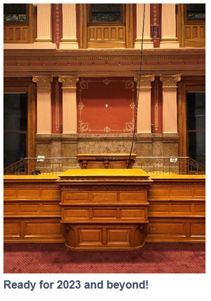
In an effort to modernize and upgrade the Chamber while preserving the original character and historical uniqueness, renovation crews relied on a mixture of both old and new ideas to make the updated Senate Chamber a reality. And when you’re talking about a room that’s approaching its 130th birthday, there was a lot to be done!
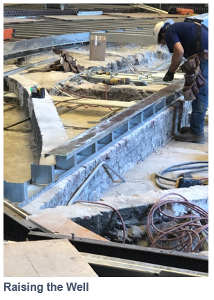
Beginning in January 2023, visitors to the Senate Chamber will probably discover a space that looks and feels very familiar with a handful of noticeable changes, such as the new elevated and relocated “well”, or speaking area for Senators, and the larger and more ergonomic amendment clerk desk. The updates have left the Chamber looking like a newer, shinier, brighter version of itself, while also improving safety and accessibility for those who conduct their business within its walls.
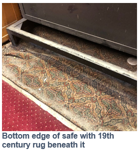
Blending the old with the new in a building as ornate as the Capitol was not without challenges, but the renovations allowed crews to improve upon existing and beloved structures within the Chamber. Highlights included restoring all 35 Senator desks and the Senate Staff front desk, which were all original to the space; polishing and restoring all existing brass fixtures; updating the Senate lobby, including adding a new President’s Marble; carefully replicating the original filigree stenciling on the Chamber walls; sandblasting and painting the metal vents; and preserving a long-forgotten nineteenth-century rug that lay quietly for decades underneath the historic bill safe.
Renovating the Chamber’s Floors
Arguably, the largest change to the Chamber is one that most visitors will never see: a completely renovated floor and sub-floor. One of the primary motivations behind this round of updates to the Chamber was to make the room more resistant to fire, and construction crews accomplished this through several months of diligent efforts and precise “floor work”.
Once a team of movers took all the desks out of the Chamber in early July, it became possible to begin the massive task of removing, updating, and reapplying the materials that make up the Senate’s large floor.
OLLS staff and all who visited the Capitol over the summer will likely remember the extensive scaffolding on the south side of the building that was present throughout the warmer months. Construction crews used this scaffolding to support a “rubbish chute” made of linked trash cans so they could more efficiently remove debris and trash from the Chamber during the project.
What, exactly, had to be done? First, contractors carefully removed the original floorboards, made of Douglas fir, as well as the three inches of unexpected concrete they found underneath. These workers then spent approximately the next month reinforcing and rebuilding the sub-floor using steel joists and new concrete panels before carefully replacing the top layer of flooring.
In addition to its reinforced floor and new out-of-sight sub-floor, the Chamber now contains new carpet that very closely resembles the pattern and color of the original carpet. The room is still predominantly red and gold and will feel much like it did during the 2022 session, but those who look closely will notice the beauty in the details brought out by months of hard work over the summer and fall.
One hidden feature is a time capsule that Senate Staff carefully prepared and that the renovation crew placed in a corner of the Chamber deep below the new carpet. Newspapers and miscellaneous items from 2022 will help freeze time inside the capsule and, decades or even centuries into the future when the Senate floor is renovated once more, crews will discover a new piece of Colorado history.
An Improved Audio Experience
While the Chamber floor was undergoing renovations, the construction team also made significant updates to the access points for the AV and IT systems that run throughout the new flooring system. Future maintenance and updates should prove much easier than in the past as a result of the renovations, and those using hearing aids will also have an easier time listening to floor proceedings during future sessions.
A “hearing loop” system now exists within the floor structure in the Senate Chamber, and this loop will provide an improved listening experience for all users with a T-Coil feature on their hearing aid. Going forward, compatible hearing aids will also have the functionality to stream audio during session straight from the Senate using an app.
Paving the Way for Future Sessions
As the decade-long series of renovations in the Senate Chamber winds down, Senate staff are excited and hopeful about how the changes will improve time spent in the Chamber for years to come. The space is now more fireproof, more accessible for those with disabilities, and more modern from the inside out.
From the more efficient electrical setup and the 2022 time capsule that now both live beneath the floor to the sparkling golden fixtures throughout, the renovated Senate Chamber honors the Colorado Capitol’s architectural history while making room for a smoother, more modern and streamlined user experience during future sessions.


